Hi-tech platform helps map Australian flood damage
Hi-Tech
South Australian aerial mapping company Aeormetrix has used its MetroMap aerial imagery service to assist in recovery efforts from the New South Wales floods.
Key Contacts

Sign up to receive notifications about new stories in this category.
Thank you for subscribing to story notifications.
MetroMap is an online aerial imagery subscription service with highly accurate geospatial data viewed through a web browser interface, to which Aerometrex has added 3D models.
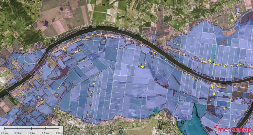
Aerometrex utilised new technical developments to its MetroMap platform to provide immediate support to the NSW Flood Emergency Services response to the once-in-100-year floods.
AeroMeterx Chief Operating Officer David Byrne said AeroMeterx did a one-off capture of the NSW country towns of Kempsey and Port Macquarie to access the flood imagery.
The data was then combined and analysed within the MetroMap platform, which incorporates synthetic aperture radar satellite imagery of the flooded areas from the COPERNICUS Emergency Management Service, NSW government data, the Geoscape building footprint and cadastral dataset, and their own aerial image library.
The result was then used to map the landscape and produce a list of property addresses and specific buildings potentially affected by the flooding.
This information was then made available to the organisations directly involved in managing and helping communities recover over the coming months such as emergency services, local government and insurance agencies.
“This provided another means for people to be able to access that data in a more usable way, where the combination of data sets together and some identification of impacted properties,” Byrne said.
“We are able to access third-party data and essentially display very rapidly any geospatial data whether it’s for a particular purpose or MetroMap platform.
“We will be moving towards providing more analytical data on top of the imagery moving forward through its development cycle.”
Aerometrex Managing Director Mark Deuter said the response showed how the MetroMap platform could provide mission-critical data.
“The scale of this disaster makes it extremely difficult to identify and assist individual people who have been affected on a case-by-case basis,” Deuter said.
“The advanced analytical techniques developed by our team and supported by our data partners provides this information within days of receiving the satellite imagery.”
MetroMaps platform has been used in previous disaster management efforts, such as mapping the Adelaide Hills following the Cudlee Creek Bushfires in South Australia in December 2019.
It is also used to assist with construction, engineering, architecture, real estate, traffic management and environmental management.
Jump to next article